Our previous studies examining variation in access to sporting facilities in relation to socio-economic patterns in Wales have been predicated on an assumption of private travel as the means of transport. We are now including travel distances and times for alternative modes of transport as part of our accessibility calculations. These are derived from an examination of open data sources, such as public transport timetables and road network data, allowing our research to consider the consequences of adopting alternative means of travel to a wide range of facility types.
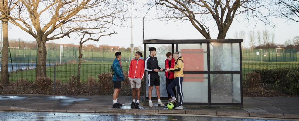
Geographical accessibility came to the fore during the pandemic, when the temporary closure of pitches, leisure centres and swimming pools appears to have led to limited opportunities to engage in physical activity in some neighbourhoods. Since then, a Welsh Parliament Senedd Committee report highlighted concerns regarding the absence of physical activity opportunities and access to public transport provision in some of the communities in Wales that exhibit the lowest rates of sports participation. In written and oral evidence to the Committee’s enquiry, individuals representing a range of sports organisations drew attention to the importance of geography and the lack of any means of reaching facilities in several parts of Wales that compound the wider barriers facing individuals’ access to physical exercise opportunities.
However, such concerns actually predate the pandemic and highlight how unequal access to high-quality facilities for those living in the most disadvantaged areas of the country can influence levels of participation. At the same time, findings from a recent Sport Wales survey of levels of activity among school children has shown a decline in those taking part in organised sports, and also widening disparities in participation in organised sport between pupils living in the least and most deprived areas since 2018. Such disparities may be exacerbated in those areas lacking affordable transport options.
In our latest study, we have confined our definition of active travel to walking and cycling but acknowledge the wider definitions of others that extend active modes to include any form of “travel in which the sustained physical exertion of the traveller directly contributes to their motion”. Exploratory GIS-based tools were developed to allow walking and cycling modes to be included alongside private and public transport to examine spatial patterns of provision. Access was captured and analysed using isochrones (polygons depicting those areas deemed to be reachable from a given starting point within a given travel time) that were constructed independently for each mode of transport (Figure 1).
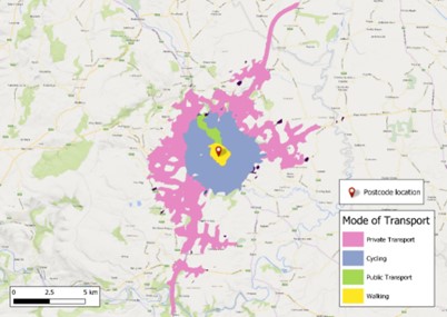
Figure 1: Illustration of varying isochrones associated with alternative modes of travel.
By computing transit times for alternative travel modes to a range of sporting facilities, the aim of this research has been to measure accessibility at national and local scales through the use of a suitable transport network dataset and an associated routing engine. Maps were drawn to illustrate how the chosen mode of transport contributes to geographical variations in access; for example, in Figure 2 the potential access to gyms/fitness suites in the North and South Wales regions are shown for public transport (bus and train), for active travel (cycling), and for private transport (car).
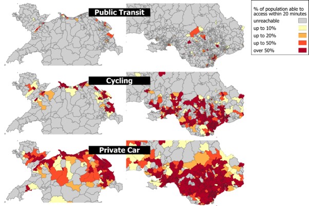
Figure 2: Comparisons of the proportion of lower super output area (LSOA) population identified as being able to reach a gym/fitness suite within 20 minutes’ travel via alternative transport modes.
Maps such as these could be used by sports organisations to plan levels of provision in relation to potential demand.
There are real concerns that geographical and socio-economic disparities in access may intensify if the cost-of-living crisis and rising energy costs lead to the potential closure of facilities such as swimming pools and leisure centres. Such pressures are highlighted in a report by the Culture, Welsh Language and International Relations Committee on the impact of increased costs on culture and sport, and the likelihood of either reductions in opening hours or permanent closure of venues, on physical and mental health and well-being.
Monitoring the impact of such changes on patterns of provision of recreational opportunities could adopt the types of approach described here as well as more advanced techniques that also consider the ‘activity space’ of individuals using such facilities. Pressures on services and issues of transport affordability add further impetus to the need to continually monitor access to facilities and to understand the potential impacts of variations in access on levels of physical activity in deprived communities.
Future research could benefit from more information being collected on the actual facilities being used, whether users are travelling from home, school, or workplace locations, the times engaged in physical activity, the modes of transport being used, and can be extended to widen the range of physical activity opportunities being studied. Such data sources could be used within spatial approaches that better facilitate national sport governing bodies and other stakeholders to target support aimed at increasing sports and physical activity opportunities. Including active and public transport routes within such models could also help to address the Welsh Government’s wider public health and climate change goals.