Mae'r cynnwys hwn ar gael yn Saesneg yn unig.
Within England and Wales, March 21st, 2021 is census day. Taking place every 10 years, the census provides the most accurate estimate of the population and a detailed account about people and the households in which they live.
The data is vital to understanding our society and in providing information that is necessary to support the delivery of public services. The census is also an invaluable resource for genealogists, providing a snapshot of family members including where they lived, who they lived with and the jobs that they held. Under the 1920 Census Act, which provides the Office for National Statistics with the authority to conduct a census for England and Wales, household level census returns cannot be published until a hundred years have passed. Family historians therefore do not have much longer to wait until they can gain access to records from the 1921 census.
Historical census data has also been integral to research conducted by WISERD that has explored the persistence of union membership within coalmining areas. It has long been recognised that within areas where there is an historical legacy of trade unionism, workers remain more likely to join trade unions due to the favourable attitudes towards union membership that persist. In the US, the economist Thomas Holmes has demonstrated how higher unionisation rates in care homes and grocery stores in West Virginia and Pennsylvania are linked to the unionisation of the old coal and steel sectors in those areas. Within the UK, colliery villages and towns located in areas once dominated by coalmining are regarded as among the strongest and most durable bases for the trade union movement. However, their direct effect on levels of union membership had not previously been assessed. By using definitions of coalfield areas based on census data, we can explore how proximity to these areas is associated with present day levels of union membership.
Within the UK, employment in coalmining peaked in 1920 at 1.19 million. The sector was highly unionised, with the Miners Federation of Great Britain having around 945,000 members, equivalent to approximately 80% of the mining workforce. Across many parts of the UK miners often lived in small, isolated communities within rural environments that they dominated. Data from the 1921 census, which had to be postponed from April to June due to a miners’ strike, reveals the true significance of mining within particular localities. In the North East of England, within both the mining districts of Easington in Country Durham and Ashington in Northumberland, approximately three quarters of males were employed in mining. Such figures were replicated across many districts of South Wales, including Nantyglo/Blaina (77%); Rhondda (74%); MynyddIslwyn (74%) and Abertillery (73%). In the Midlands, 70% of males living in Bolsover in Derbyshire and Huthwaite in Nottinghamshire worked in mining. Mining and trade unionism defined the very character of these and many other coalfield communities.
Fast forward 60 years and by 1981 employment in coalmining had fallen to approximately 170,000. Colleagues at the Centre for Regional, Economic and Social Research at Sheffield Hallam University have used 1981 census data to derive a definition of coalfields for the UK. Based upon ward level data, coalfields are broadly defined as those areas where 10% or more of male residents in employment worked in the coal industry in 1981. The definition of coalfields was subsequently expanded to include two additional old coalfields that had already lost their workforce by 1981: Gloucestershire and Cumbria. The 1981 census was the last to be taken before the major colliery closures that led to the year-long strike by miners in 1984/5 and the eventual erosion of the industry. It takes a snapshot of that moment of stability between the major rundown of coalmining in the 1960s and the eventual end of mining.
To examine the historical effect of mining on trade union membership, the coalfield boundaries derived from the 1981 census have been combined with data from the Labour Force Survey1 , the main source of data regarding union membership in the UK. Figure 1 shows the boundaries of these coalfields and how they relate to small area estimates of the rate of union membership derived from the Labour Force Survey. This data can be accessed via WISERD’s UnionMaps service.
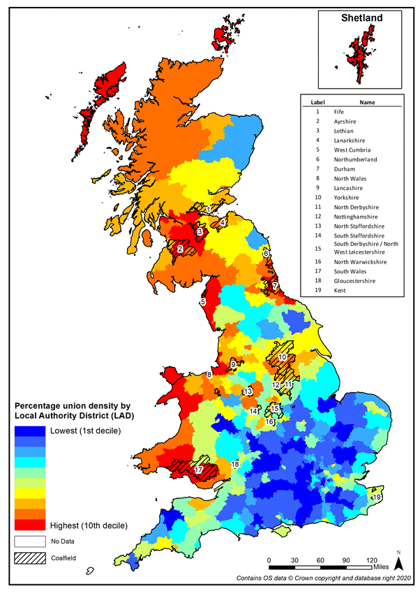
Figure 1: Coalfields and Small Area Estimates of Union Membership (% employees)
Analysis reveals that union membership remains higher among those who live within coalfield boundaries (32%) than those who live elsewhere (25%). This difference cannot simply be accounted for by the presence of more unionised workplaces within these areas. What is perhaps more surprising is that the effect of living near these areas on union membership diminishes sharply with respect to how far away those in employment live from the boundaries of these coalfields as demonstrated in the Figure below. More detailed statistical analysis that controls for the different characteristics of workers and their jobs confirms that those living just a few kilometres beyond the boundaries of coalfield areas are significantly less likely to be union members than those who live within.
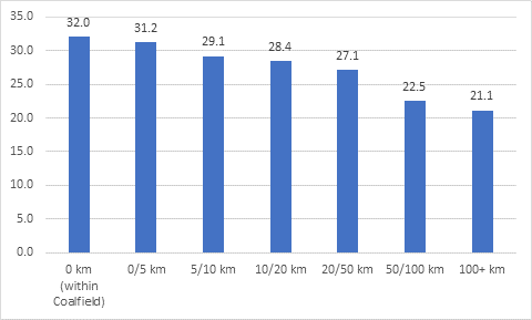
Figure 2: Proximity to Coalfields and Union Membership (% employees).
Our research therefore demonstrates how current rates of unionisation are strongly linked to historical rates of unionisation via the ‘long shadow’ cast by industries, which while no longer present, incubated high levels of union experience in their heyday. Mining areas across Great Britain remain important conduits for trade union membership, long after employment within the sector has vanished.
While previous studies have demonstrated the variations that exist in union membership across broad geographical areas, our analysis demonstrates that understanding spatial variance in trade union membership requires a detailed geographical analysis at the sub-regional level that can account for the complexities of industrial heritage. Census data has been vital to us in terms of discerning how locality and history contribute to our understanding of present-day levels of union membership.
Data from WISERD’s UnionMaps service reveal the fascinating differences in union membership that exist between different parts of the UK. Why not find out how high union membership is in your area?
Read our paper: The Persistence of Union Membership within the Coalfields of Britain.
[1]Office for National Statistics, Social Survey Division, Northern Ireland Statistics and Research Agency, Central Survey Unit (2020). Quarterly Labour Force Survey, 1992-2020: Secure Access. [data collection]. 18th Edition. UK Data Service. SN: 6727, http://doi.org/10.5255.UKDA-SN-6727-20.